Assessing Hurricanes with Remote Sensing Techniques
Recovering from a natural disaster involves immense efforts, such as addressing significant effects on local communities, ecosystem structures, and natural habitats.
In a study, published in the Open Access Journal of Marine Sciences and Engineering (JMSE), researchers from Florida Atlantic University developed a novel technique using a combination of remote sensing technologies to provide a rapid, high-resolution post-hurricane assessment.
For the first time, researchers utilised light detection and ranging (LiDAR) and aerial imagery to remotely assess beach morphology changes in barrier islands and assess residential structural damage. The team created a multifaceted approach by combining the light detection remote sensing method with aerial imagery datasets. This novel remote sensing approach aids in developing a conceptual framework that integrates assessments of beach morphological changes, debris and sediment deposition, and structural damage evaluation.
Following the catastrophic Hurricane Ian in the United States, the researchers aim to provide a detailed analysis of the structural damage and debris deposition in relation to the morphological changes of the barrier islands. This article explores the innovative study, working towards minimising the reliance on traditional field surveys, thereby streamlining the collection of time-sensitive data.
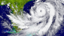
Hurricane Ian
In September 2022, Category 4 Hurricane Ian made landfall near Cayo Costa in Lee County, southwestern Florida. According to the Atlantic Oceanographic & Meteorological Laboratory at the National Oceanic & Atmospheric Administration (NOAA), only 32 hurricanes have made landfall as a category 4 storm or higher in the continental U.S. since records began in 1851.
The hurricane had devastating impacts on the affected communities. The event resulted in the loss of lives, flooding, residential structural damage, and significant coastal changes that eroded coastal habitats. Hurricane Ian severely battered the region with wind speeds of 155 miles per hour and a catastrophic storm surge of up to 13 feet. This was one of the highest storm surges documented in Southwest Florida in the past 150 years.
Hurricane recovery
In the aftermath of a natural disaster, rapidly assessing damage is crucial for rescue, recovery, and emergency planning. Remote sensing techniques have become essential for conducting damage assessments and monitoring coastal changes. The aim of these remote sensing technologies is to improve recovery planning and enact more effective policies to enhance community resilience in the face of such devastating events.
“Although our study focused on Estero Island, this new remote sensing approach is generalisable.” – Dr Diana Mitsova, author on the paper.
Typically, teams conduct damage assessments through field reconnaissance deployments, which can be labour-intensive, costly and risky. However, field-based emergency response assessments can face delays and other setbacks due to the severity of the damage and the inability to access the hardest-hit areas.
Applying remote sensing after hurricane events
To tackle the challenges that traditional surveys face, the researchers turned to aerial imagery data and airborne LiDAR point cloud data. They combined these technologies to identify the severely affected areas of Southwest Florida’s Estero Island and estimated the extent of structural damage and coastal structural changes. Additionally, the researchers compared pre- and post-storm structural and morphological changes to the beach. This study represents the first application of an advanced multi-faceted approach linking damage assessment to post-storm changes in the structure of barrier islands.
Prior research has predominantly examined the impacts of hurricanes using remote sensing technologies. However, the researchers highlight a gap in the literature, emphasising the limited attention given to applying a multi-faceted approach that connects damage assessment with post-storm changes in barrier island morphology.
Analysing the structural damage
In the study, the researchers identified a total of 2,427 structures on Estero Island that were impacted by Hurricane Ian, with 170 structures suffering extensive damage. A single store was the only structure in the study area classified as ‘not affected’.
Overall, the researchers found that 734 buildings suffered from 5 to 30% structural damage, the majority of which were single-family and multi-unit residences. They also discovered that 158 buildings suffered severe damage with partial or complete roof failure.
The researchers measured this structural damage using LiDAR tools to extract building footprints and building heights pre- and post-storm. Building footprints were overlaid on the post-imagery to estimate the total number of damaged buildings as well as the level of damage to each structure.
“Employing this advanced technology of aerial imagery and airborne LiDAR enabled us to collect extensive data from Hurricane Ian’s aftermath and analyse large-scale datasets rather quickly.” – Dr Tiffany Roberts Briggs, author on the paper.
The areas associated with little to no damage from Hurricane Ian were spatially clustered in the southern and central portion of the island, with most structures concentrated on the landward side of the barrier island.
Analysing the beach morphology changes
The researchers found substantial post-storm debris and sand deposition across the entire Estero Island. They also found a notable deposition of sediment across the roadways and on the backside of the barrier. This raises an environmental concern because the sediment does not readily return seaward to the beach under post-storm conditions. They also found ponding water hundreds of meters inland near buildings and other structures, providing evidence of the extent of inundation resulting from the storm.
Impacts of coastal erosion
Natural disasters, such as hurricanes, pose a significant threat to communities situated along coastal areas through the erosion of sands and destruction of saltwater marshes. When these events disrupt the intricate system of sand or marshes, these areas become increasingly susceptible to coastal erosion. Additionally, these natural systems act as buffers during severe weather events, playing a crucial role in protecting coastal communities.
During Hurricane Ian, the researchers emphasised the role of saltwater marshes in the southern portion of Estero Island. These marshes helped substantially dissipate storm-wave energy through friction, reducing the impact on structures in the urbanised area.
Future of multi-faceted remote sensing
The use of remote sensing data, such as LiDAR and aerial imagery, as showcased in this study, underscores the potential of these technologies to advance rapid post-storm assessment. These applications can also reduce the dependence on field survey methods for the collection of time-sensitive data after hurricanes and other natural disaster events.
“As this technology continues to advance and becomes more readily available, it will offer a broad range of high-resolution coverage that can help prioritise emergency response efforts immediately following catastrophic natural disasters and other events.” – Dr Mitsova
Future research
If you’re interested in learning more about this research, you can access the paper published in JMSE. If you would like to read more research in this area, please see the JMSE Special Issue “Natural and Human Impacts in Coastal Areas” for more information.